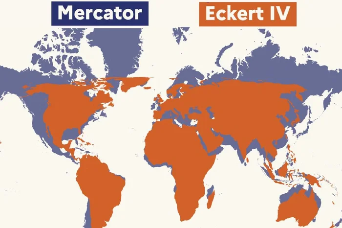
The French government has announced that it will no longer use the Mercator map projection in its diplomatic efforts. This decision follows a historic resolution adopted by the United Nations General Assembly on September 4, 2026. The resolution aims to promote a more accurate representation of the world's continents. It was championed by Togo and several other African countries, and supported by European Union countries, including France.
The Mercator projection has been widely used for navigation purposes, but it has been criticized for distorting the size of countries located at high latitudes. The resolution encourages international organizations and countries to use the Equal Earth map projection, which provides a more accurate representation of the world's continents. The French government sees this move as a way to contribute to a more balanced and less biased representation of the world's continents.
The resolution, also known as "Correct the Map," was co-sponsored by France and was adopted by 164 votes, with one vote against and six abstentions. The United States was the only country to vote against the resolution. The French government considers this move a "strong symbolic gesture" that reflects its commitment to building a partnership of equals with African countries.
The French Ministry of Europe and Foreign Affairs stated that the decision to abandon the Mercator projection is part of a broader effort to promote a more accurate representation of the world's continents. The ministry emphasized that maps play a significant role in shaping our understanding of the world and that they can perpetuate erroneous representations if they are not accurate.
The move is seen as a significant step towards promoting a more nuanced understanding of the world's geography. The French government hopes that its decision will inspire other countries to follow suit and adopt more accurate map projections. This effort is part of a broader initiative to promote a more balanced and equitable representation of the world's continents.
The Togolese Minister of Foreign Affairs, Robert Dussey, emphasized the importance of accurate maps in shaping our understanding of the world. He stated that maps are not neutral and can perpetuate erroneous representations if they are not accurate. The French government sees its decision as a way to contribute to a more accurate and nuanced understanding of the world's geography.
The adoption of the Equal Earth map projection by France is seen as a significant development in the field of international relations. The French government hopes that its decision will contribute to a more balanced and equitable representation of the world's continents. This move is part of a broader effort to promote a more nuanced understanding of the world's geography and to build a more equitable partnership between France and African countries.
Key points
- France has abandoned the Mercator map projection in its diplomatic efforts, adopting the Equal Earth map projection instead.
- The decision follows a historic resolution adopted by the United Nations General Assembly on September 4, 2026.
- The move aims to promote a more accurate and balanced representation of the world's continents.