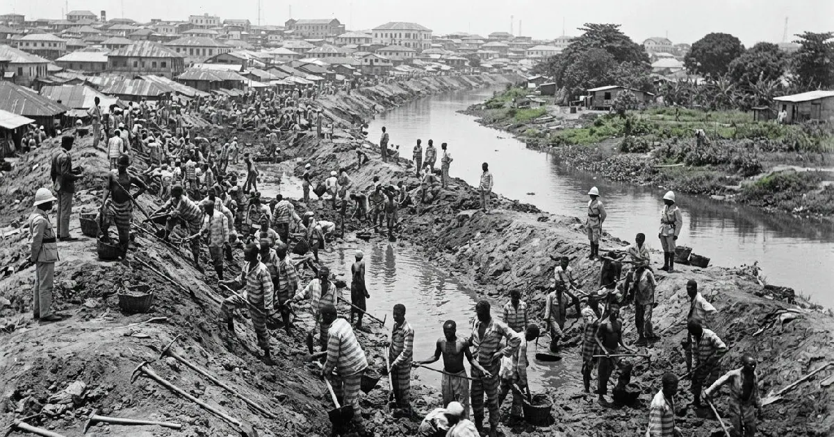
The MacGregor Canal, a significant colonial project, was constructed between 1903 and 1904 during the administration of Governor Sir William MacGregor. This 25-foot-wide artificial waterway was initially intended to improve public health by draining swamps and combating malaria. However, its impact extended far beyond sanitation, physically separating Lagos Island and Ikoyi, areas previously joined, and fundamentally redefining urban space and social hierarchy. The project was a substantial undertaking that required the labor of prisoners from the colonial prison.
Governor Sir William MacGregor, a Scottish medical doctor and colonial administrator, governed Lagos from 1899 to 1904. He had a personal stake in eradicating malaria, having nearly died from the disease in 1903. Medical research at the time had established the link between mosquitoes and malaria, making drainage and environmental sanitation key colonial policy. Lagos presented an enormous environmental challenge, with low-lying land, lagoons, tidal flats, and vast swampy areas that were ideal breeding grounds for mosquitoes.
The MacGregor Canal was designed to be a central channel within a wider drainage network. Smaller drains serving the swampy ground between Lagos town and a nearby area discharged into it, using tidal movement to improve overall drainage. The excavation of the canal generated vast quantities of earth, which was used to reclaim the surrounding swamp land, particularly the notorious Kokomaiko Swamp. This newly available land was quickly deemed suitable for roads, buildings, and development.
The labor behind the project was immense, with prisoners from the colonial prison employed daily on swamp reclamation work. These incarcerated individuals contributed directly to the canal's excavation, forming an important, yet often overlooked, part of the workforce that physically created modern Lagos. The reliance on forced labor adds a dark layer to the narrative of colonial development.
When the canal was completed, it linked significant waterways and sliced through Lagos Island, creating an artificial boundary that proved far more significant than its sanitary function. By 1908, official descriptions of the city recognized this new division, with colonial legislation describing land situated east of the MacGregor Canal as belonging to the area generally known as Ikoyi. A bridge was soon constructed over the canal, connecting Obalende to the newly defined area of Ikoyi.
The physical separation rapidly translated into social segregation, with Ikoyi evolving into an exclusive "European-only quarter" or "European reservation." Nigerians were largely excluded from residing in Ikoyi, except for those employed as servants by the colonial residents. This created a stark contrast with the bustling, densely populated Lagos Island, marking a deliberate social stratification enforced through urban planning and land use policies.
The legacy of the MacGregor Canal extends beyond its initial purpose, with the canal's history not ending with its completion or the formal demarcation of Ikoyi. In the 1970s, parts of the canal were sand-filled to construct an inner ring road around Lagos Island. However, the social distinction that the canal had helped cement persisted, with residents of Ikoyi still grappling with the consequences of historical land reclamation.
Key points
- The MacGregor Canal was initially intended to improve public health by draining swamps and combating malaria.
- The project physically separated Lagos Island and Ikoyi, areas previously joined, and fundamentally redefined urban space and social hierarchy.
- The labor behind the project was immense, with prisoners from the colonial prison employed daily on swamp reclamation work.