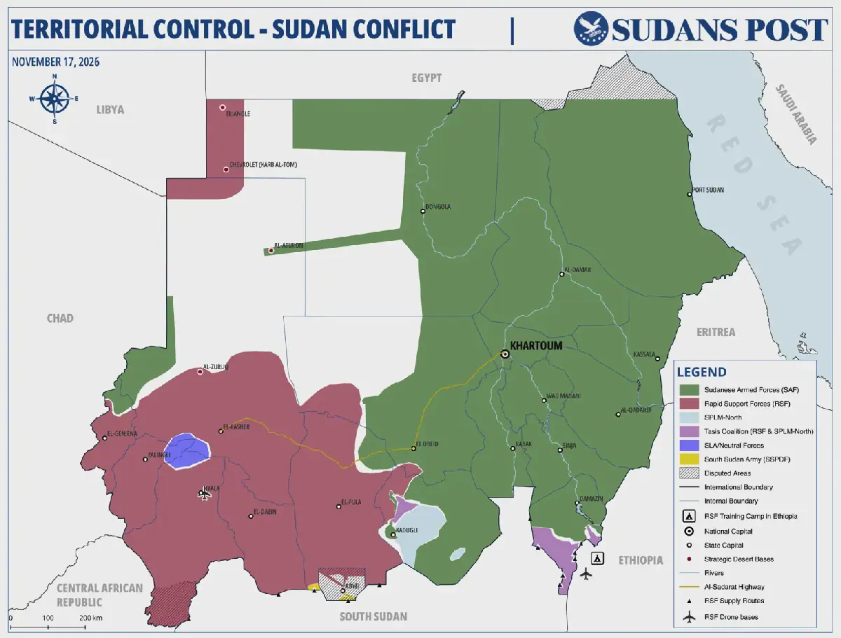
The Sudanese Armed Forces (SAF) and allied armed groups have expanded their control across North Kordofan and pushed into neighbouring West Kordofan, recapturing several towns and villages from the Rapid Support Forces (RSF). A new territorial control map prepared by Sudans Post as of November 17 shows government-aligned forces holding most of North Kordofan and a growing section of northeastern West Kordofan, including Al-Khuwai.
The army's latest gains have brought its forces to Al-Morkib, approximately 60 kilometres east of Al-Nahud, one of the RSF's principal strongholds in West Kordofan. The city sits along the Al-Sadarat Highway, also known as the Al-Inqaz Al-Qarbi Highway, which passes through Wad Banda Locality toward North Darfur. The offensive represents the army's most significant westward advance since it began recovering territory in North Kordofan earlier this year.
On November 5, army units and fighters from the Joint Force of former Darfur rebel movements launched attacks west and south of El-Obeid, capturing Umm Sumayma and several surrounding settlements. The operation was followed by further advances southwest of the city and from northern North Kordofan toward the West Kordofan border.
On November 13, government-aligned forces entered Al-Khuwai, the administrative headquarters of Al-Khuwai Locality, after capturing Serif Ankoush, Umm Labana, Al-Dudiya and other nearby villages. Sudans Post verified and geolocated footage showing Joint Force fighters outside Al-Khuwai Locality headquarters, while separate footage placed members of the allied Al-Baraa Ibn Malik militia at the town's police headquarters.
The advance continued on November 14, when army and allied forces captured Al-Morkib, Khamasat, Umm Oweisha and several villages east of Al-Nahud. On November 16, an army special operations spokesman also announced the capture of Al-Sa'atat, an area comprising five settlements northeast of Abu Zabad.
Despite the latest government gains, the RSF still controls the overwhelming majority of West Kordofan, including Al-Nahud, Al-Fula, Abu Zabad, Babanusa, Al-Muglad and Heglig. Based on the territorial boundaries depicted in the November 17 Sudans Post map, the RSF holds approximately 85 to 90 percent of West Kordofan, while the army and its allies control a smaller northeastern section.
The fighting has already affected civilians, with thousands of residents fleeing Al-Nahud, Abu Zabad and other areas toward Darfur amid intensified army airstrikes and fears of further fighting. The Dar Hamar Emergency Room reported strikes on RSF positions in Al-Nahud and several surrounding localities, while residents described families leaving in vehicles as the military confrontation approached populated areas.
Key points
- The Sudanese army has made significant gains in West Kordofan, recapturing several towns and villages from the RSF.
- The army's advance has brought it to within reach of Al-Nahud, a key stronghold of the RSF in West Kordofan.
- The fighting has led to a significant displacement of civilians, with thousands fleeing toward Darfur.
Reporting sources
- Territorial Control Map – Sudan Conflict (as of November 17, 2026) · sudanspost.com