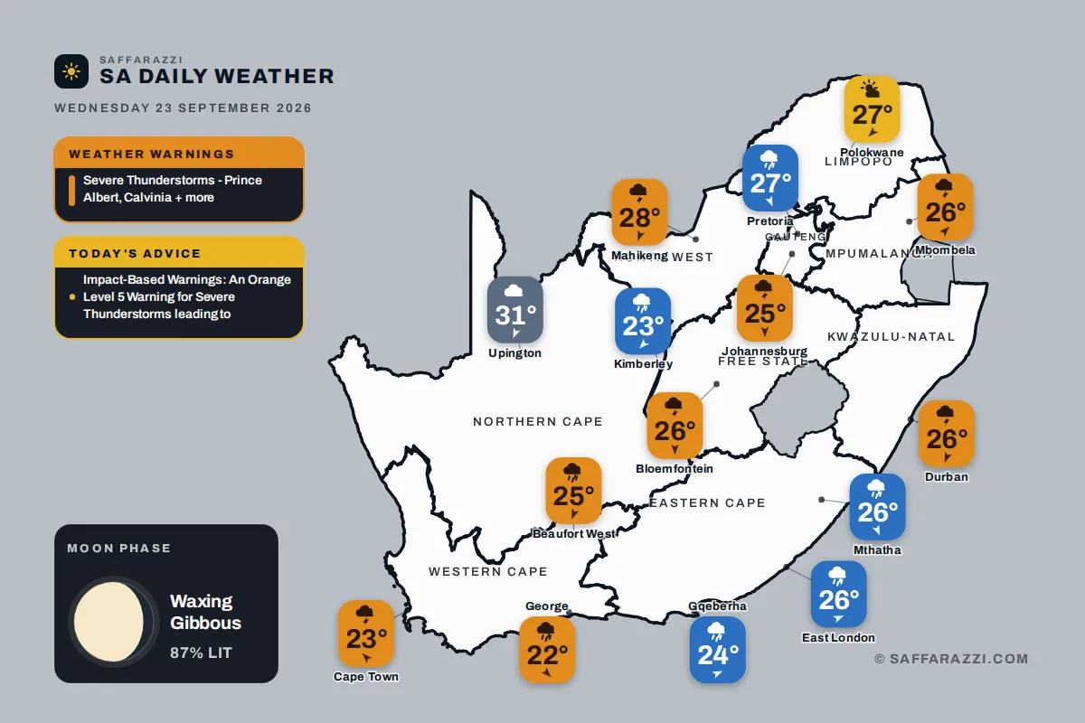
A low-pressure system has brought wet and unsettled weather to much of South Africa, with showers and thundershowers expected across several provinces, including Gauteng, the Western Cape, KwaZulu-Natal, the Free State, Mpumalanga, and North West. The Eastern Cape and Northern Cape can also expect rain showers. This unstable weather pattern is expected to persist throughout the day, with temperatures ranging from a cool 11 degrees in Johannesburg to a warm 28 degrees in Mahikeng.
The South African Weather Service has issued several severe thunderstorm warnings, mostly of moderate severity, due to the potential for large amounts of small hail, strong winds, and heavy downpours. These conditions can lead to major travel disruptions, loss of livestock and agricultural productions, and disruption to essential services. Residents are advised to take necessary precautions and stay informed about the latest weather updates.
An Orange Level 5 Warning for Severe Thunderstorms has been issued for the Hantam, Karoo Hoogland Districts of the Northern Cape, and the Central Karoo District of the Western Cape. This warning indicates a high risk of injuries and danger to life, large amounts of small hail, damage or loss of infrastructure, settlements, and vehicles. Residents in these areas are advised to stay indoors, avoid traveling, and take necessary precautions to ensure their safety.
In addition to the Orange Level 5 Warning, a Yellow Level 2 Warning for Severe Thunderstorms has been issued for several areas, including Grabouw, Worcester, Knysna, and Cape Town. This warning indicates a moderate risk of localised damage to vehicles, excessive lightning, large amounts of small hail, and localised damage to infrastructure. Residents in these areas are advised to stay indoors, avoid outdoor activities, and take necessary precautions to ensure their safety.
The severe thunderstorm warnings are not limited to the Western Cape and Northern Cape. A Yellow Level 2 Warning for Severe Thunderstorms has also been issued for Escourt, Ekuvukeni, Ladysmith, and other areas in KwaZulu-Natal. This warning indicates a moderate risk of localised damage to infrastructure and settlements, localised flooding of susceptible roads and bridges, and minor motor vehicle accidents due to slippery roads and poor visibility.
The Moon is currently in its waxing gibbous phase, with 87% illumination. It rises at 15:39 and sets at 04:44. The next full moon is expected on Saturday, September 26, and the next new moon is expected on Sunday, October 11. Weather conditions are expected to vary across different provinces, with partly cloudy and warm weather expected in Gauteng, and cloudy and cool to warm weather expected in the Western Cape.
Provincial weather forecasts indicate that Gauteng can expect partly cloudy and warm weather with isolated showers and thundershowers. The expected UVB sunburn index is high. In the Western Cape, morning fog is expected along the west coast, otherwise cloudy and cool to warm with scattered showers and thundershowers but isolated over the West Coast. Residents are advised to check the latest weather forecasts and warnings for their specific area to ensure their safety.
Key points
- An Orange Level 5 Warning for Severe Thunderstorms has been issued for the Hantam, Karoo Hoogland Districts of the Northern Cape, and the Central Karoo District of the Western Cape.
- A Yellow Level 2 Warning for Severe Thunderstorms has been issued for several areas, including Grabouw, Worcester, Knysna, and Cape Town.
- The severe thunderstorm warnings are expected to persist throughout the day, with residents advised to take necessary precautions and stay informed about the latest weather updates.