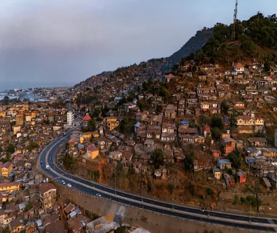
A Facebook user, BORN 2 BLOG, shared an aerial image showing the skyline of a densely populated urban area along a coastline, claiming it was taken in Sierra Leone. The post, which had attracted over 100 likes, 11 comments, and two reshares as of September 17, 2026, sparked some debate among users. Some users believed the image to be genuine, with one commenting "Beautiful." However, others were skeptical, with one user suggesting it was "Pure AI."
Dubawa, a fact-checking organization, investigated the photo and ran it through two AI image-detection tools: AI Image Detector and Image Detector. Both tools returned a 97% probability that the image was AI-generated. The AI Image Detector also labelled the image as "fake" with high confidence. This initial finding prompted Dubawa to conduct further verification.
Dubawa compared the image in the claim with an aerial photograph published on Pexels showing the actual Hillside Bypass area of Freetown. The comparison revealed significant differences between the two images. In the image posted by BORN 2 BLOG, the highway appears to pass through a relatively low and broadly spread urban landscape. The surrounding buildings also appear unusually uniform and densely arranged.
In contrast, the genuine aerial view shows the road surrounded by the distinctive steep terrain of the Hillside and Mount Aureol communities. The residential settlements rise visibly up the hills, while the road follows the terrain rather than running through a relatively flat urban landscape. The Hillside Bypass runs along the steep hillside below Fourah Bay College, with densely populated communities rising around the road.
The OPEC Fund, which financed the Hillside Bypass Road project, describes it as a 3.7-kilometre, four-lane east-west bypass in Freetown. This geographical description provides an independently documented feature against which the social media image can be compared. The actual aerial photograph used for comparison shows the pronounced hillside settlement around the road, whereas the circulated image presents a substantially different landscape.
Dubawa also reviewed YouTube video footage, which provides another real-life view of the Hillside Bypass and its surrounding landscape. The road, hillside settlements, and general physical environment match the actual aerial photograph much more closely than the image circulated by BORN 2 BLOG. Additionally, Dubawa noticed a watermark on the image: "Gwen J. Koroma's viewpoint."
The Facebook post is false, according to Dubawa's investigation. The image shows features consistent with AI generation, and although it resembles an aerial view of Freetown, it does not depict the actual view of Sierra Leone's Hillside Bypass. The page associated with the watermark, Gwen J. Koroma's viewpoint, contains aerial views of cities, some of which have been modified by AI tools to make them look more pleasant.
Key points
- The image was found to be AI-generated with a 97% probability by two separate image-detection tools.
- The image does not match the actual aerial view of Sierra Leone's Hillside Bypass, according to a comparison with a genuine aerial photograph.
- The Facebook post is false, and the image does not depict the actual view of Sierra Leone's Hillside Bypass.