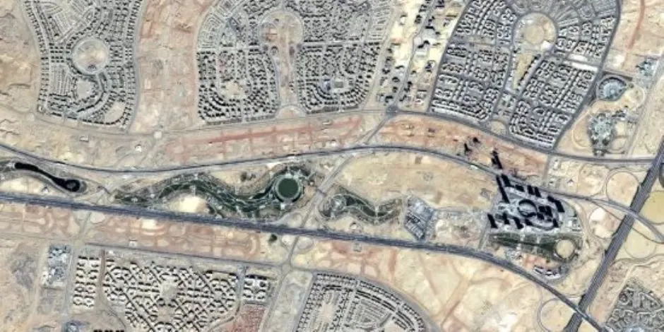
The Egyptian Space Agency has released a satellite image of the new administrative capital, captured by the EgyptSat-2 satellite. The image shows a part of the residential area of the new capital, along with a section of the Green River and the iconic tower. This image not only documents the urban landscape of the new capital from space but also provides valuable data and information for monitoring urban expansion and analyzing road networks.
The image provides important data for planners, developers, and investors, supporting site studies, project implementation monitoring, and planning and decision-making processes. The data from these satellite images can be used to track changes and urban growth rates over time. The Egyptian Space Agency's National Center for Space Data is responsible for processing the satellite images and converting them into maps, indicators, and informative products.
These products can be used in various fields, including urban planning, project monitoring, and site studies. The Egyptian Space Agency plays a crucial role in utilizing satellite technology and data to support development plans and enhance the information system and decision-making process. The agency's efforts aim to leverage space technology for the benefit of Egypt's development.
The new administrative capital is a significant project, and the satellite images provide a unique perspective on its development. The images can be used to monitor the project's progress, identify areas of growth, and make informed decisions about future development. The Egyptian Space Agency's work in this area demonstrates its commitment to using space technology to support Egypt's development goals.
The EgyptSat-2 satellite is an important tool for the Egyptian Space Agency, providing valuable data and images for various applications. The satellite's capabilities enable it to capture high-quality images of the Earth's surface, which can be used for a range of purposes, including urban planning, environmental monitoring, and disaster management.
The release of the satellite image of the new administrative capital demonstrates the Egyptian Space Agency's ability to provide accurate and timely data for development projects. The agency's work in this area is critical for supporting Egypt's development goals and enhancing the country's infrastructure.
The use of satellite technology for urban planning and development is becoming increasingly important in Egypt. The Egyptian Space Agency's efforts in this area are expected to continue, providing valuable data and insights for development projects across the country.
Key points
- The Egyptian Space Agency released a satellite image of the new administrative capital, captured by the EgyptSat-2 satellite, showing the residential area, Green River, and iconic tower.
- The image provides valuable data for planners, developers, and investors, supporting site studies, project implementation monitoring, and planning and decision-making processes.
- The Egyptian Space Agency plays a crucial role in utilizing satellite technology and data to support development plans and enhance the information system and decision-making process.